Search results for map
that are a tweet
See all the search results for this query

"Voyage" by #ValBritton draws on the language of maps, inspired by information pertaining to San Francisco International Airport, such as maps, plans, weather patterns and flight routes. #airportart
This tweet was posted on July 27, 2018.
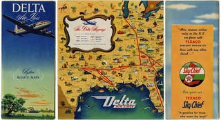
.@Delta has added a few more routes since their 1946 system map: #aviation #routemap
This tweet was posted on June 19, 2015.
2 years in NYC made such an impression on Josef Frank that he made designs from city maps: http://t.co/95mpNsTQ Where's your fav city?
This tweet was posted on October 21, 2011.
@ATCPeter Not at the moment, but we’ll be making many of our route maps available online in the near future.
This tweet was posted on July 30, 2014.
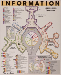
@Chanceb737 Our Aviation Museum & Library is in the Intl Term; other exhibits are thru the terminals. Overall map: http://t.co/Q4k0UVWE
This tweet was posted on November 19, 2012.
@TelstarLogistic Thanks! And it's a small world- our next exhibit in Terminal 2 is of maps, some from the David Rumsey collection.
This tweet was posted on October 09, 2013.
@friscolex @TheRealWBTC The map exhibit is so new that it hasn't been installed yet. Should be up by Friday. Glad it's already a hit! :)
This tweet was posted on December 10, 2013.
@mwichary Glad you enjoyed the exhibit! Select maps are on our website; high res via David's: http://t.co/mKAzkxdmKb (cc: @DavidRumseyMaps)
This tweet was posted on January 24, 2014.
@robpegoraro Thanks for noticing! :) We'll have to see if we can get added to the map.
This tweet was posted on November 29, 2011.
@roldan4317 Microscopes are pre-TSA, in the Int'l Term, A-side; red dot on map here: http://t.co/gEtCwvHl We'd love to hear what you think!
This tweet was posted on June 05, 2012.
@tmccormick A map showing which exhibits are pre-security can be found here: http://t.co/hdcfMG7n3g
This tweet was posted on December 02, 2013.
A City of Industry! San Francisco was a busy, bustling metropolis, as depicted in this map from 1878: http://t.co/L37CXn92dq #maps #sfmaps
This tweet was posted on March 06, 2014.
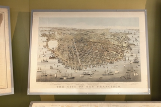
A scene of San Francisco in 1862, via a nine-foot long, panoramic map of the city by Charles B.… http://t.co/xU4o3mZutC
This tweet was posted on December 27, 2013.
AWESOME. Every library & museum in America mapped by @TheAtlantic http://t.co/IWANT6eiCd #MuseumLove #FeelGoodFriday (via @HeatherKLake)
This tweet was posted on June 07, 2013.
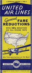
Airline route maps have been printed since the 1920s. Check out our online database of route maps: https://t.co/0g3kXvbu8u #avgeek
This tweet was posted on October 16, 2016.
American Airlines thoughtfully included a 'cloud atlas' in their 1939 system map: http://t.co/FTOM8A6Kxy #routemap
This tweet was posted on November 18, 2014.
An 1849 map of SF shows the underpinnings of today's city after a whopping 2,400% population growth in 2 yrs: http://t.co/QMLVC4JMLB #sfmaps
This tweet was posted on December 26, 2013.
An engraved scene of the San Francisco Bay, courtesy of a map from 1859: http://t.co/7D9L3Tjdcw #maps #sfmaps
This tweet was posted on April 11, 2014.
Announcement, map, & award for Repack, the 2.1 mile, 1,300-foot descent mountain bike race that birthed a gl http://t.co/ViOb3C2s
This tweet was posted on October 02, 2012.
As passenger numbers swelled in the 1980s, SFO began upgrading amenities and providing an increasing array of concessions. This 1990 map of SFO shows all amenities available at the time, including our art exhibits and even a video arcade! #avgeek #SFOHistory
This tweet was posted on July 19, 2018.
Can you imagine Mission Street ending at not one, but two horse racing tracks? Many gems in this 1859 #map! http://t.co/H5PcE09NYn #sfmaps
This tweet was posted on January 27, 2014.
Classic font treatment from this 1869 San Francisco map. More on display at #SFOMuseum #david rumsey http://t.co/2MevIIQg4R
This tweet was posted on January 08, 2014.
Detial: this 1885 #map of Chinatown reveals the businesses of San Francisco's 'city within a city': http://t.co/AJ7ZQy6xrv #SFmaps
This tweet was posted on June 27, 2014.
Even in 1861 and surrounded by vast ranchos, the shape of San Francisco is easily recognizable: http://t.co/UiqQLzwkvZ #maps #sfmaps
This tweet was posted on May 28, 2014.
Famed aviator Charles Lindbergh helped map TWA’s early routes, earning the airline the nickname, “The Lindbergh Line” http://t.co/W5i7VOG7PD
This tweet was posted on May 19, 2014.
Faust's Map and Guide of San Francisco, a handy folding map of the city published in 1882, included a… http://t.co/ozzhmPIyjR
This tweet was posted on September 16, 2014.
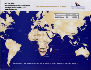
Flying to over 35 destinations around the world, this map shows all of South African Airways' (SAA) international destinations from circa 2005. Have you ever been to #SouthAfrica? #TravelTuesday
This tweet was posted on December 05, 2017.
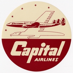
For its brand, a stylized eagle symbol was developed with a rigid, airplane-like wing that blended the natural with the mechanical. The eagle flew under a constellation of stars arrayed like destinations on a route map. #DefunctThursday #CapitalAirlines #AvGeek
This tweet was posted on March 10, 2022.
Google Maps vs Fred Lyon's 1952 pic, Kearny Street above Broadway. Where are the people? http://t.co/L4ktcYVap5 & http://t.co/IbgBT8rHFB
This tweet was posted on April 30, 2013.
Gorgeous 1929 air travel map gives new meaning to the word 'detailed': http://t.co/lQcLbsR1jC via @paleofuture & @TelstarLogistic #avgeek
This tweet was posted on October 09, 2013.
Happy #EarthDay! “Green Map” by #EllenHarvey inverts the traditional idea of a map to highlight the region’s green space. Instead of focusing on cities, towns and roads, this map features places like Mount Tamalpais and Point Reyes National Seashore. #MuseumFromHome
This tweet was posted on April 22, 2020.
Happy Birthday San Francisco! SF was incorporated #onthisday in 1850. In 2013, we presented “San Francisco: From the David Rumsey Map Collection” which featured maps of our fair city from the latter half of the nineteenth century to the twentieth century. https://t.co/dx9IyBEHeW
This tweet was posted on April 15, 2020.
Have we mentioned that we've launched a new digital playground? It's a work in progress with much more to come, but we've got a blog going at https://t.co/zEnBYU1UmW and we've been having a lot of fun with old #maps of @flySFO at https://t.co/pz6xehOt8q
This tweet was posted on August 07, 2018.
Heading through T2? Check out our exhibit on early maps of San Francisco to learn how the city came to… http://t.co/tZoD25Ax3M
This tweet was posted on March 14, 2014.
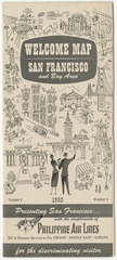
How many SF landmarks can you name from this 1950 map distributed by Philippine Air Lines? #SFHistory
This tweet was posted on August 12, 2016.
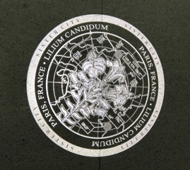
In "Shining Paths: San Francisco's Sister Cities" by #LewisDesoto's each Sister City is represented by the aeronautical map for its airport, overlaid with the image of the city flower. #airportart
This tweet was posted on August 11, 2018.