@SFOMuseum Twitter Posts Tagged map This is SFO Museum's archive of the @SFOMuseum Twitter account. There are 6 posts . See all the tags or all the Twitter posts that have been archived so far.
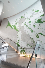
See “Green Map” by Ellen Harvey on display, in the Grand Hyatt Hotel and online at: https://t.co/izglNdUuXI
#EarthMonth #EllenHarvey #PublicArt #mosaic #map
This tweet was posted on April 25, 2023.
The Farallon Islands were well known by the 1860s, warranting a small but detailed corner in this 1861 #map: http://t.co/46tAUKHiGk #sfmaps
This tweet was posted on September 26, 2014.
Detial: this 1885 #map of Chinatown reveals the businesses of San Francisco's 'city within a city': http://t.co/AJ7ZQy6xrv #SFmaps
This tweet was posted on June 27, 2014.
SF's recovery from the 1906 earthquake is evident in this 1915 #map: skyscrapers, transit & the Panama-Pacific Expo: http://t.co/2jpqAIhn9n
This tweet was posted on April 23, 2014.
Land in SF has always been a heated topic. Early disputes & settlements are documented in an 1861 #map: http://t.co/vp8ajjCTW0 #sfmaps
This tweet was posted on February 19, 2014.
Can you imagine Mission Street ending at not one, but two horse racing tracks? Many gems in this 1859 #map! http://t.co/H5PcE09NYn #sfmaps
This tweet was posted on January 27, 2014.