@SFOMuseum Twitter Posts Tagged maps This is SFO Museum's archive of the @SFOMuseum Twitter account. There are 8 posts . See all the tags or all the Twitter posts that have been archived so far.
Read about the work that went into creating the map project, early iterations of the interactive application, and what can happen when aerial images are “georectified”: https://t.co/eQl34NCMoz
#maps #cartography #SFHistory
This tweet was posted on February 15, 2022.
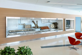
Part of the “Mills Field and the San Francisco Airport” exhibition, the interactive map installation allows visitors to change the viewport to better understand the scale and velocity of changes that have been made to the Airport’s campus. #maps #cartography #SFHistory
This tweet was posted on February 15, 2022.
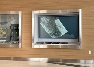
NEW Blog Alert! Check out “Interactive Historic Maps of SFO from 1930 to 2021” by our resident tech wizard, Aaron Cope. Learn more about this installation in the SkyTerrace observation deck in Terminal 2. https://t.co/eQl34NCMoz #maps #cartography #SFHistory
This tweet was posted on February 15, 2022.
Have we mentioned that we've launched a new digital playground? It's a work in progress with much more to come, but we've got a blog going at https://t.co/zEnBYU1UmW and we've been having a lot of fun with old #maps of @flySFO at https://t.co/pz6xehOt8q
This tweet was posted on August 07, 2018.
Even in 1861 and surrounded by vast ranchos, the shape of San Francisco is easily recognizable: http://t.co/UiqQLzwkvZ #maps #sfmaps
This tweet was posted on May 28, 2014.
An engraved scene of the San Francisco Bay, courtesy of a map from 1859: http://t.co/7D9L3Tjdcw #maps #sfmaps
This tweet was posted on April 11, 2014.
A City of Industry! San Francisco was a busy, bustling metropolis, as depicted in this map from 1878: http://t.co/L37CXn92dq #maps #sfmaps
This tweet was posted on March 06, 2014.
The hidden world of women cartographers: http://t.co/Ac2PaPqLfe Great article via @Marilyn_Res & @NatGeo #maps #sfmaps
This tweet was posted on January 31, 2014.