- Any -
    Home
    • Exhibitions
      • Current Exhibitions
      • Past Exhibitions
      • Upcoming Exhibitions
      • Gallery Map
    • Aviation Museum & Library
      • Collection
      • Research Appointments
      • Donating
      • Volunteering
      • Support Affiliate
      • Events
      • Hours & Directions
    • Public Art
      • Overview
      • Public Art Collection
      • Public Art Map
    • Programs
      • Video Arts
      • Photography
      • Student Art
      • Education Program
      • Kids' Spot
    • About
      • History
      • Press Releases
      • Blog
      • Employment
      • FAQs
      • Visitor Survey
      • Contact
      • Image Permissions

    Main navigation (mobile)

    • Exhibitions
      • Current Exhibitions
      • Past Exhibitions
      • Upcoming Exhibitions
      • Gallery Map
    • Aviation Museum & Library
      • Overview
      • Collection
      • Research Appointments
      • Donating
      • Volunteering
      • Support Affiliate
      • Events
      • Hours & Directions
    • Public Art
      • Overview
      • Public Art Collection
      • Public Art Map
    • Programs
      • Overview
      • Video Arts
      • Photography
      • Student Art
      • Education Program
      • Kids' Spot
    • About
      • Overview
      • History
      • Press Releases
      • Blog
      • Employment
      • FAQs
      • Visitor Survey
      • Contact
      • Image Permissions
    Mills Field
    • Collection
    • Airfield
    • Map
    • Social Media
    • Developers
    • Weblog

    Breadcrumb

    @SFOMuseum Twitter Posts Tagged cartography This is SFO Museum's archive of the @SFOMuseum Twitter account. There are 3 posts . See all the tags or all the Twitter posts that have been archived so far.

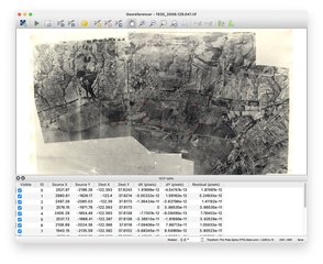
    Read about the work that went into creating the map project, early iterations of the interactive application, and what can happen when aerial images are “georectified”: https://t.co/eQl34NCMoz #maps #cartography #SFHistory This tweet was posted on February 15, 2022.
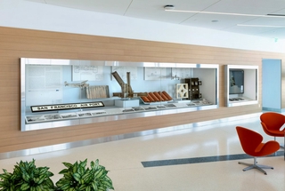
    Part of the “Mills Field and the San Francisco Airport” exhibition, the interactive map installation allows visitors to change the viewport to better understand the scale and velocity of changes that have been made to the Airport’s campus. #maps #cartography #SFHistory This tweet was posted on February 15, 2022.
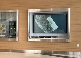
    NEW Blog Alert! Check out “Interactive Historic Maps of SFO from 1930 to 2021” by our resident tech wizard, Aaron Cope. Learn more about this installation in the SkyTerrace observation deck in Terminal 2. https://t.co/eQl34NCMoz #maps #cartography #SFHistory This tweet was posted on February 15, 2022.
    Sign up for announcements

    SFO Museum

    Footer menu

    • Visit FlySFO
    • Contact
    • Image Permissions

    Main navigation (Footer)

    • Exhibitions
      • Current Exhibitions
      • Past Exhibitions
      • Upcoming Exhibitions
      • Gallery Map
    • Aviation Museum & Library
      • Overview
      • Collection
      • Research Appointments
      • Donating
      • Volunteering
      • Support Affiliate
      • Events
      • Hours & Directions
    • Public Art
      • Overview
      • Public Art Collection
      • Public Art Map
    • Programs
      • Overview
      • Video Arts
      • Photography
      • Student Art
      • Education Program
      • Kids' Spot
    • About
      • Overview
      • History
      • Press Releases
      • Blog
      • Employment
      • FAQs
      • Visitor Survey
      • Contact
      • Image Permissions

    Footer bottom

    • FAQs
    • Privacy

    © San Francisco International Airport